Oh, the irony is rich with the latest weather model runs. From a set of convective blobs near Mexico, a potential tropical cyclone may emerge and move into the Gulf of Mexico. Our best weather models are increasingly trending towards the storm developing. If the storm reaches tropical storm status (and it is a bit early to say that with certainty), it would take the name “Nestor.” Nestor was a mythical character in the Odyssey and the Iliad. The Gulf States, including Alabama, should watch this storm closely. Ironically, Alabama was at the center of controversy recently as National Weather Service-Birmingham meteorologists snuffed out misinformation about a “mythical” hurricane threat along the Alabama coastline from Dorian. Here’s what we know about the current weather system at this point.
Tropical disturbance that could become a tropical storm by Friday
NOAA
The 2 pm Tropical Weather Outlook on October 16th from the National Hurricane Center is a great place to start:
A broad area of low pressure located just offshore of the coast of southern Mexico, in the Bay of Campeche, is producing disorganized showers and thunderstorms. Gradual development is possible, and a tropical or subtropical cyclone could form late this week over the western or central Gulf of Mexico while the system is moving generally northeastward. Regardless of development, this system could produce gusty winds, rainfall, and rough surf along portions of the northern Gulf Coast Friday and Saturday.
NOAA’s top tropical weather experts give the storm a 50% chance of development over the next 2 to 5 days and an Air Force Reserve reconnaissance aircraft stands ready to fly into the storm Thursday as necessary.
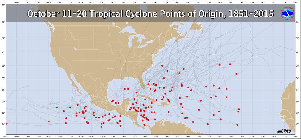
We are certainly still within the Atlantic basin hurricane season, and there is nothing particularly odd about a tropical system forming in this location. The climatology of where tropical cyclones have formed during the October 11-20 from 1851 to 2015 shows a cluster of origin points near the Bay of Campeche region.

Climatological origin points for tropical cyclones in mid-October
NOAA/NWS
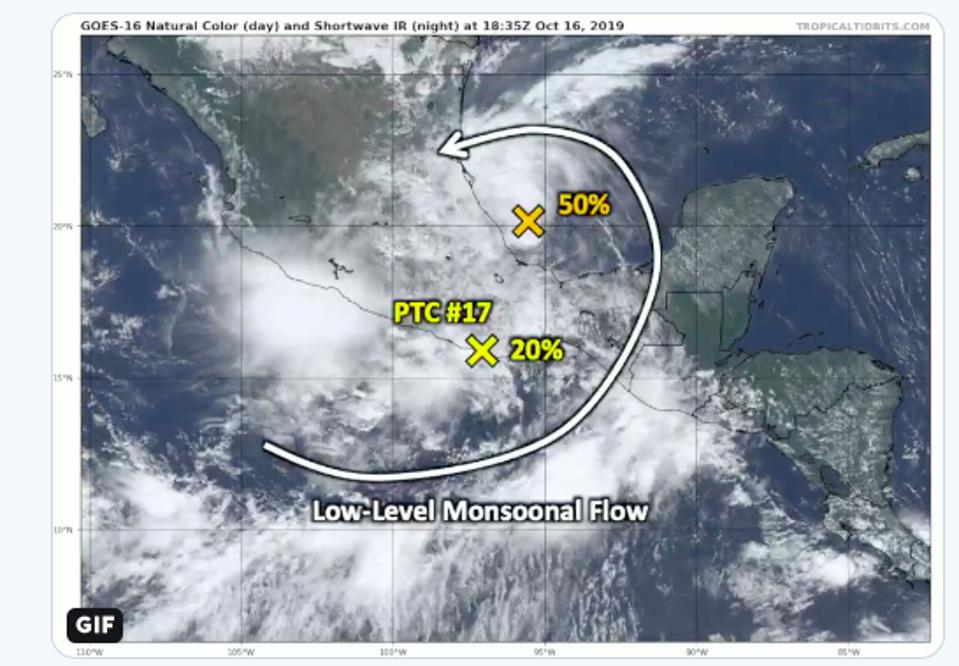
There is still uncertainty about the system and its evolution. For example, tropical meteorology expert Dr. Philippe Papin tweeted the following statement and graphic:
Even though #PTC17 has failed to become a TC (tropical cyclone), the larger monsoonal flow (earlier associated with a #CAG) continues to result in widespread rainfall over #Mexico. Another vortex is forming in the Bay of Campeche & now stands the best shot to become a TC over the next 48 hours.

Two different tropical systems near the Bay of Campeche. One could eventually form into a tropical system affecting the Gulf States.
Philippe Papin/TropicalTidbits.com/NOAA
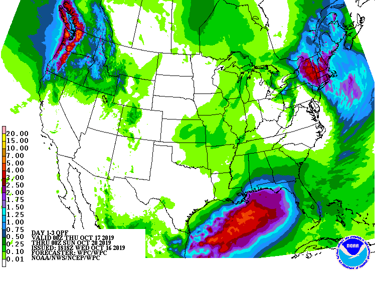
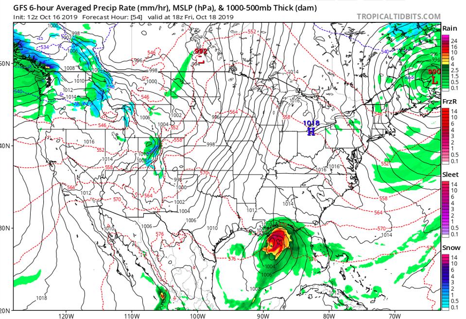
My current review of the models finds that the American GFS has a fairly aggressive scenario by Friday evening. It spins up a tropical storm in the Gulf that is just off the Alabama, Mississippi, and Louisiana coast. Other models, including the “Euro” model, are also bullish on a similar scenario. Even if the storm never reaches tropical storm status, it will still be a significant rain producer. Much of the Southeast has been in a flash drought so the rainfall is certainly welcomed.

Projected rainfall totals from Friday to Sunday
NOAA WPC
At this point, it is important to understand the uncertainties and our meteorological tools. Do you know what the “cone of uncertainty” actually conveys (click here if you are unsure)? Do you know what lines are most credible when you see the “spaghetti plots?” Do you know what a percentage threat actually means? There is always uncertainty in weather model outcomes so we convey messages that account for it. As we see with “Sharpie-gate” and on social media, probabilistic weather information can be misused or misinterpreted by the untrained user. Here’s a thought. Ask someone who is trained to know.

American GFS model has a tropical storm near the Gulf Coast by Friday afternoon.
NOAA/TropicalTidbits.com
